Official USAAF Bomb Fall Plot map dated September 3, 1944, documenting the pinpoint bombing precision of B-17 Flying Fortresses targeting the Belgrade railway bridge.
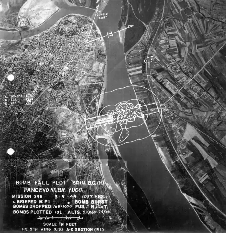
Official Bomb Fall Plot Map: Belgrade Railway Bridge Strike (September 3, 1944)
This remarkable aerial reconnaissance photo-map, produced by the A-2 Intelligence Section (Photo Interpretation) of the HQ 5th Bombardment Wing (USAAF), documents the pinpoint precision achieved during Mission No. 338 against the Pančevo Railroad Bridge (Prince Peter II Bridge) in Belgrade Yugoslavia, on September 3, 1944.
The overlay graphics and plotted impact coordinates demonstrate the empirical methodology used by Allied intelligence officers to evaluate the tactical success of strategic heavy bomber operations in Southeastern Europe.
Technical Flight Data and Raid Metrics
The operational annotation block on the photograph records explicit mission telemetry from the strike executed by the 301st Bombardment Group (Heavy) operating B-17 Flying Fortress aircraft:
- Target Identification: Pančevo Railroad Bridge (Pancevo RR. BR. Yugo.), spanning the Danube River.
- Time of Attack: 10:57 AM (1057 HRS).
- Ordnance Dropped: 168 high-explosive 1,000-pound bombs (168 x 1000 lbs) fitted with non-delay instantaneous nose fuses.
- Plotted Detonations: 102 individual bomb bursts (represented by white plotted points) mapped within the narrow tactical concentration ellipse centered on the target pier spans.
- Bombing Altitude: Extreme high altitude ranging between 22,060 and 24,500 feet (6,720 to 7,460 meters).
- Attack Approach Vector: Flight course set at 308°.
Strategic Significance of Photo Interpretation in WWII
The 97% effective targeting benchmark established during this raid was made possible through advanced bomb-aiming equipment and rigorous post-strike analysis:
- Norden Bombsight Calculations: At altitudes exceeding 22,000 feet, lead bombardiers used gyroscopically stabilized Norden bombsights to calculate airspeed, crosswind drift, and altitude, releasing bomb loads in tight formation patterns.
- Impact Plotting (Bomb Fall Plot): Aerial photo interpreters analyzed post-strike imagery to count water splashes and ground craters, determining structural damage without sending ground reconnaissance teams into enemy-controlled territory.
- Paralyzing Axis Evacuation: The documented collapse of the Belgrade bridge spans effectively closed the main rail transit route for retreating German forces withdrawing from Greece and Yugoslavia toward Hungary and Austria.
📍 Location: Belgrade, Kingdom of Yugoslavia
📅 Date: September 3, 1944
📷 Photographer: Reconnaissance Camera, 5th Bomb Wing (USAAF)
📰 Primary Source: US National Archives (NARA) / 301st Bombardment Group Records

Recommended reading:
- Combat operations of the 301st Bombardment Group (H) in the Mediterranean Theater
- Aerial Photo Interpretation (P.I.) methods in the USAAF 5th Bomb Wing
- High-altitude precision bombing techniques with the Norden Bombsight
- Operation Ratweek: Interdicting Axis withdrawal through the Balkans (1944)